For those that followed my previous travels, you are aware that I often intermix information that provides a historical context about where I travel, and that will not change.
When Karen and I set out from Philomath, for the first 3 days – it is about 600 miles to the Canada border – we will be following the path of humongous Missoula Floods, which occurred at the end of the last Ice Age, only 10,000 years ago.
I became interested in this geologic phenomenon when I lived and worked for the Department of Energy in Richland, WA, at the Hanford Site – where all of the plutonium fuel for America’s nuke weapons was manufactured and now the largest Superfund site in the US. I digress, but Hanford was an extremely interesting place to work for a year and a half and it provided easy access to some unbelievably spectacular landscapes…….
I have read about half a dozen books on the Missoula floods, spent dozens of hours pouring over maps and have traveled the landscape of their multiple paths, numerous times. As much of the Columbia River drainage and eastern WA is now rock – devoid of topsoil – as a result of the floods, the results of the floods are easily observed by one that knows what to look for.
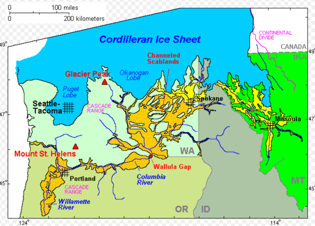
At the end of the last Ice Age, a huge ice sheet thousands of feet thick covered Canada. It scoured the Great Lakes and went as far south as Seattle and New York City. In the panhandle of Idaho, near Sandpoint and Lake Pend Oreille, the ice sheet created an ice dam across the Clark Fork River, (named by the Corps of Discovery) resulting in a giant lake – Glacial Lake Missoula – that was over 2000 feet deep and that went all the way over to Missoula, MT, and up to Glacier NP and Flathead Lake, over 200 miles away.
Just take a moment and think about a lake over 200 miles long, dozens of miles wide and over 2000 feet deep.
Then imagine the consequences of all that water being suddenly released in matter of days, racing downhill to the Pacific Ocean, about 700 miles away. Geologists believe the floods occurred approximately 100 times over about 2000 years when the glacial ice dam suddenly ruptured. About every 100 years a new ice dam was created, and lake another lake was formed…….and over and over and over.
AI Overview from a quick Google search:
The Glacial Lake Missoula floods were catastrophic events where a massive amount of water was released from a glacial lake in Montana.
The estimated volume of water released during each flood varied, but generally, it was:
- Around 500-600 cubic miles of water.
- This is about half the volume of modern-day Lake Michigan.
- It’s also estimated to be more water than in Lake Erie and Lake Ontario combined.
- The total potential energy released by each flood was immense, equivalent to 4,500 megatons of TNT.
The peak flow rate of these floods was astonishing:
- Estimated at 10 times the combined flow of all the rivers on Earth.
- Some estimates put the maximum flow rate at 600 million cubic feet per second.
- The water velocities were incredibly high, reaching speeds of 56-100 mph.
The sheer volume and speed of the Missoula floods dramatically reshaped the landscape of the Pacific Northwest, carving out features like the Channeled Scablands, the Grand Coulee, Potholes, Dry Falls, the Columbia Gorge and contributing significantly to the agricultural richness of the Willamette Valley.
So, my followers, there was an enormous amount of water almost instantly released multiple times across eastern WA and down the Columbia River. The gravel and silt debris deposits in the Portland basin in places is over 250 feet deep and in places the silt in the Willamette Valley is over 100 feet thick.
I have read that it is believed it only took several days for each succesive lake to empty.
A screenshot of a satellite photo clearly shows where all of this silt came from – the Palouse topsoils that were washed away from eastern WA west and southwest of Spokane WA, now named the Channeled Scablands.
Where did the Palouse topsoils come from you may wonder. Volcanic ash that blew east from Mts. Rainier, St. Helens, Adams and Hood.

.
Here are some links to more detailed information:
https://en.wikipedia.org/wiki/Missoula_floods
https://www.nps.gov/iafl/planyourvisit/maps.htm

It is pretty obvious where much of the debris went when viewing a bathymetric map of the seafloor west of Astoria.
We will be driving through this spectacular country on our way to the Canada border.
I never tire of traveling and learning about this landscape.
So much to see, so much to imagine………

You must be logged in to post a comment.