Wednesday, December 4, 2013
The Plaine Des Jarres and “That Map”
Prepared in Late Dec 2103. Posted 1/13/14
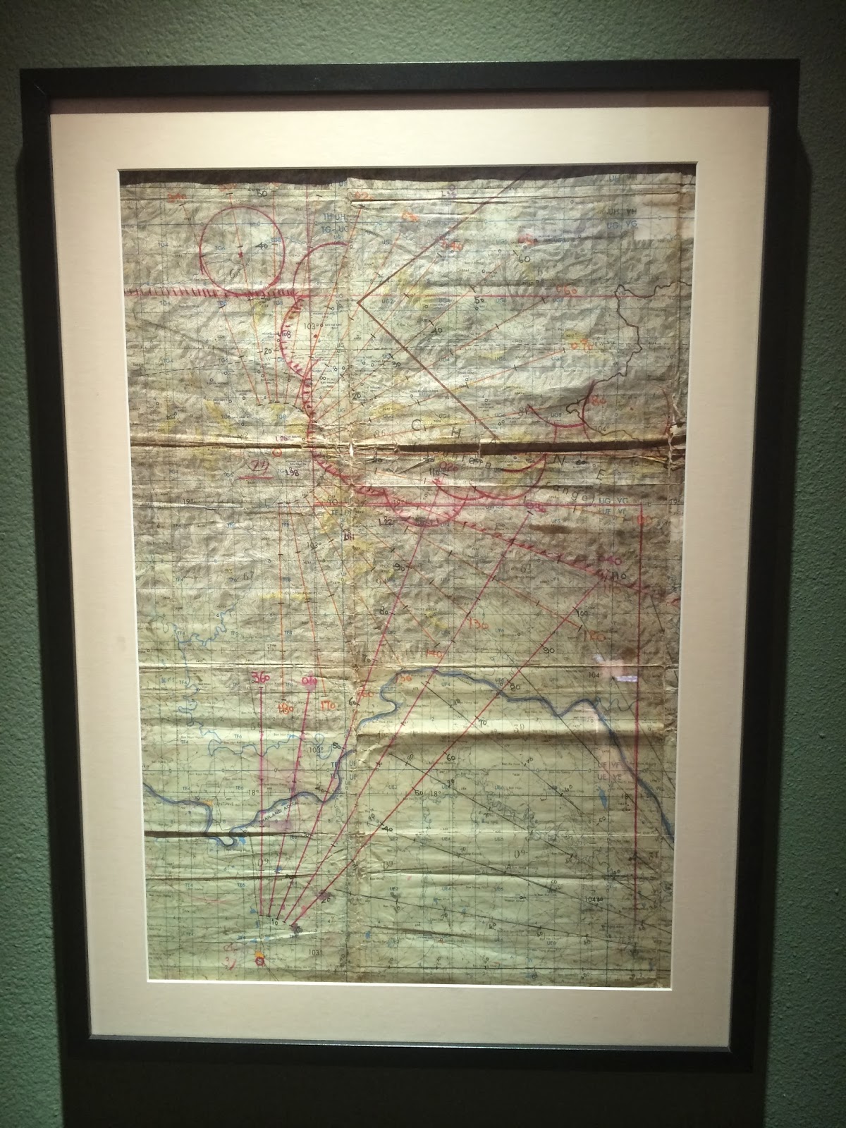
Below are several photos of a map I found squirreled away in some of my father’s things.
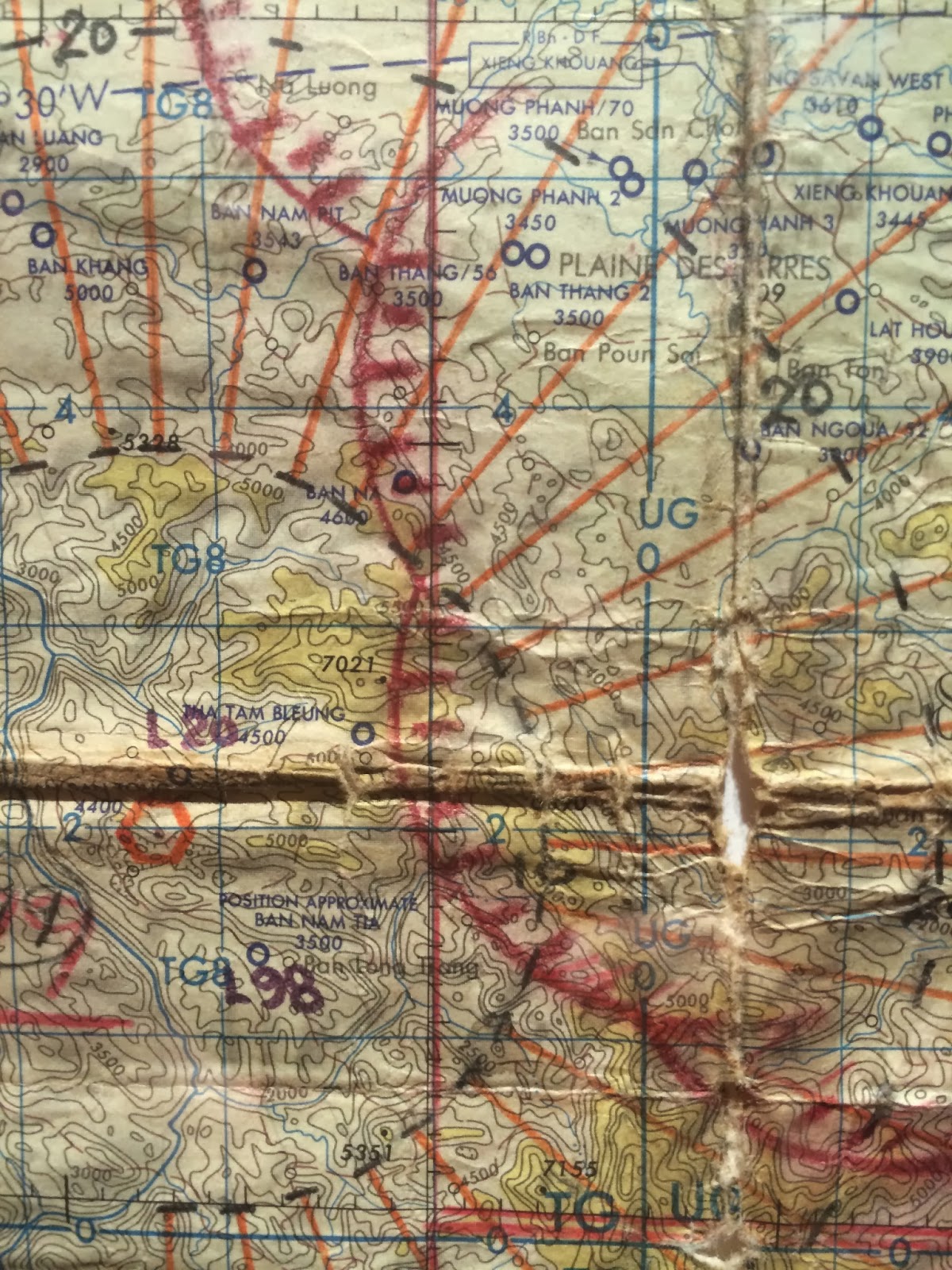
The closeup of the map at the bottom of the page shows an area about 60 to 80 miles NNE of Vientiane, Laos. L98 is Long Tieng – often described as “The Most Secret Place on Earth”.
I had the map framed and look at it daily. Considerable research resulted in an understanding of places and numbers on the map. My father never told me much about it or about what he was doing………but with much of the war in SE Asia now declassified and the power of the internet, I think I figured some of it out…….
My father drew the lines, the numbers for the radio beacons, the distances from the beacons, the landing strips (Lima Sites). All the edges were cut off the map. It had been folded, refolded, creased, crinkled, crunched and folded again. It was obvious that it had been used very heavily.
On the top right corner over the crease in the map you can see “Plaine Des Jarres” or The Plain of Jars. Much of his flying was over this region in 1966 as a USAF pilot. The war in Laos was a “Secret War”. U.S. Activity in Laos was classified until the Clinton Administration.
The CIA was running the entire show in Laos, so it was covert – everything about activity in Laos was covert. Secret. Dangerous. Officially, the U.S. was not involved in Laos. But we were, big time.
The map is full of lines, radians from radio beacons, distances, landing strips, etc. The Plain of Jars was a major link to the Ho Chi Minh trail and a primary route of transit for equipment, food and soldiers into South Viet Nam. Depending on the time of the year, (monsoon season) control of much of the region often shifted between the “good guys” and the “bad guys.”
This area that he flew over is a primary destination of my travels. To walk on the Plain of Jars. My father was not dropping bombs from his plane…but he did in WWII. That is another story and just might be the next walkabout.
In Laos, he was flying a WWII era C47 outfitted with a payload of first generation radio receiving and relay equipment, communications specialists and a Lao national or two. They communicated with Hmong ground forces, spotter aircraft (The Ravens), the inbound fighter/bombers, and the CIA in Vientiane, the Lao capital. The plane was basically an early version of AWACS.
In less than year after his missions were over, all the work stations were upgraded to a module that fit inside a C130.
Targets were ID’d by a “Raven” or a “Butterfly” flying a single engine spotter aircraft. The location was transmitted to the C47 and bombing of the coordinates was approved by Lao nationals in the C47. Fighter/bombers were called and radioed to the target coordinates. The target was marked with smoke by the Raven/Butterfly and then bombs were dropped by the fighter/bombers. Then Ravens flew back over the area and reported damage assessments.
Laos had more tons of bombs dropped on it during the war in SE Asia than all of the bombs dropped by all the planes – German, English, Japanese, American…….during WWII. The countryside is riddled with unexploded ordinance, or UXO’s. The quantity of UXO’s is unimaginable. There are still millions of UXO in Laos and hundreds of people are maimed or killed each year.
More about the jars on the Plain of Jars in a future blog.
Here is a little info on UXO’s:
Quick Facts and Figures:
- Lao PDR is the most heavily bombed country, per capita, in history
- Approximately 25% of villages in Laos are contaminated with Unexploded Ordnance (UXO)
- More than 580,000 bombing missions were conducted over Laos
- Over 2 million tons of ordnance were dropped on Laos between 1964 and 1973
- Cluster munitions or ‘Bombies’ (as they are known locally) are the most common form of UXO remaining
- More than 270 million bombies were dropped onto Laos
- Up to 30% failed to detonate
- Approximately 80 million unexploded bombies remained in Laos after the war
- All 17 provinces of Laos suffer from UXO contamination
- Over 20,000 people have been killed or injured as a result of UXO
- Over 50,000 people have been killed or injured as a result of UXO accidents in the period 1964 to 2008
- 41 out of the 46 poorest districts in Laos have UXO contamination
Check out the following link for information about Ravens doing the real dirty work and some great information about Long Tieng:
http://www.airspacemag.com/military-aviation/ravens.html
 |
| Per Wiki – regarding L98 (Lima 98) on the map above: L98 (AKA Lima 98. Later L98 was renamed L20 Alternate) or Long Tieng – was often described as “The Most Secret Place on Earth”. It was located in a valley at 3,100 feet elevation, high enough to have chilly nights and cold fogs. It was surrounded by mountains and on the northwest side of the runway were karst outcrops several hundred feet high. In the shadow of the Karst outcrops was “Sky” the CIA headquarters in Long Tieng. Jerry Daniels, a CIA officer codenamed “Hog,” is said to have named Sky after his home state of Montana, known as “Big Sky Country.”[7] Long Tieng was protected on three sides by limestone mountains.[8] “What a place is Long Tieng,” said USAID officer Jim Schill. “Tribal soldiers dressed in military garb standing next to traditionally dressed Hmong, with Thai mercenaries milling about. And the Americans here are mostly CIA operatives with goofy code names like Hog, Mr. Clean, and Junkyard. The town itself is not much. There’s one paved road running through it and tin shacks on either side with eating shops, food stalls, and living quarters.”[9] During the Secret War, Long Tieng became the largest Hmong settlement in the world.[8] In the words of one author, Long Tieng “became a desultory metropolis, an unpaved, sewerless city of 30,000 where Hmong ran noodle stands, cobbled shoes, tailored clothes, repaired radios, ran military-jeep taxi services, and interpreted for American pilots and relief workers.”[10] |
